
Humans are naturally visual creatures, making them more inclined towards something that’s drawn or has an illustration that they can follow easily. Having a drawing can also make things easier in explaining things, like how people used to use an actual map to draw and create their route on where they want to go.
These days, we use several apps to tell us where to go, but we don’t have the same experience of seeing the full journey of where we want to go compared to how we used to do it with physical maps, until recently. Just Draw It! is a route planner and distance finder app that lets users draw over possible routes on a map by dragging their fingers across their desired pathways. Users can also calculate how far each distance is, amongst other things, that make planning their morning walks, cycle rides, or long drives easier.
Deze routeplanner-app laat je simpelweg tekenen met je vinger #android https://t.co/0FVFe2QZ4E pic.twitter.com/O63NmV1wp7
— Androidworld (@Androidworld) January 13, 2021
Drawing out your route and more
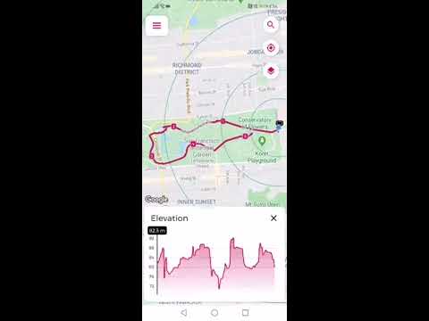
We all have been on travels that lacked planning due to lacking information such as distance, route elevation, and estimated travel time per transportation used. Just Draw It! can provide these types of information and more to make your transit smoother.
It provides tech assistance for health-conscious people that want to burn a specific number of calories each day by walking, running, or cycling, and assists travel enthusiasts by calculating and planning time, distance, and stops between starting point and destination. Just Draw It! is available on iOS and Android.
If you need a route planning app, try out Just Draw It!, it's really good ⬇️https://t.co/KfKMIrHzRh …by @MrKrisWhyNot#Android #app
— Android Headlines (@Androidheadline) April 16, 2021
Free and paid modes
The free version of Just Draw It! offers three map types: satellite, terrain, and default. You can set the map however way you want to understand your route better with the app. The free version also has a current location button, which brings the map position to your standing position so you can draw the route from your location to your destination.
Meanwhile, the VIP Plus mode of Just Draw It! is paid version that offers the app ad-free, customization of settings, street map support, auto snap to roads, route elevation, unlimited route actions, backup, and sync across all your devices. This mode also calculates the distance in many other transportation modes, such as running, hiking, scooting, cycling, car driving, sailing, boating, and many more, making your journey from point A to point B better.
YouTube: Just Draw It! Route planner and distance finder.
By clicking play, you agree to YouTube's Terms of Service and Privacy Policy. Data may be shared with YouTube/Google.
Photo credit: The feature image is taken by Jordan McQueen.